The Burren
County Clare, Ireland
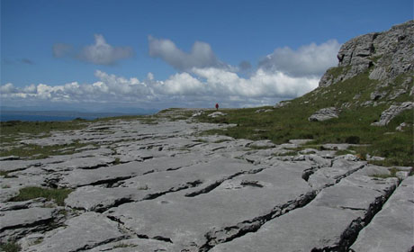
The landscape of the Burren has been shaped by geological forces for hundreds of millions of years. The story begins in a tranquil tropical sea near the equator, includes the development of a major river delta, migration and collision of continents, the expansion and contraction of the polar ice caps and last but not least, the rain that sweeps in from the Atlantic.
Rock Formation
 The rocks that make up the Burren were all formed during the Carboniferous period between 340 and 315 million years ago. This geological period is named for all the coal deposits in North America, UK and Europe that were formed at this time.
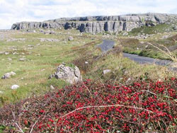
In the Burren are there are two major rock types; the lighter coloured limestones to the north and east and the darker siltstones, shales and sandstones to the south west. The limestones which make up the typical bare Burren landscape were buried by the slightly younger siltstones and sandstones which make up the Cliffs of Moher.
 The different rock types were formed under different conditions; the limestones, which contain fossil corals, crinoids and brachiopods were formed in a warm tropical sea near the equator, very much like the Bahamas today. The limestones were deposited slowly over a very long period of time, around 20 million years and much of the rock is actually made up of little bits of broken fossils.
Continental Collision and Ice Age
Much later, only about 1.8 million years ago the ice age started. Huge masses of ice over 200m thick came from the north and north east and scoured the surface ripping up soil and rock and carving valleys and then depositing the rocks and clay as the ice melted.
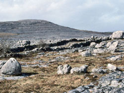
We can see these rocks scattered across the Burren as glacial erratics today. Along the coast there are many rocky beaches where it is possible to find rocks which are not originally from the Burren, these granites, red sandstones and others were carried by the ice from Connemara and east Clare and have been eroded by the sea from the glacial deposits left by the ice.
Related Links
Nearby Sites
Images (top to bottom):- The Burren © Earth Science Ireland
- Limestone Escarpment, South West Burren © Peter Craine (Source Geograph.org.uk) Creative Commons Attribution-ShareAlike 2.0 license.
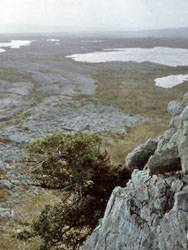
- View from Mullach Mor © Dr Charles Nelson (Source Geograph.org.uk) Creative Commons Attribution-ShareAlike 2.0 license.
- Glacial Erratics, Eastern Burren © Dr Charles Nelson (Source Geograph.org.uk) Creative Commons Attribution-ShareAlike 2.0 license.
![]()
October 13 - 21
Theme: 'Earth Science in our lives'