St Kilda
Outer Hebrides, Scotland
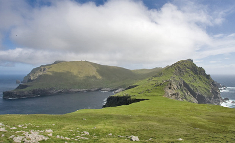
The stark islands of the St Kilda archipelago rise steeply out of the Atlantic Ocean, about 40 miles west of Harris in the Outer Hebrides.
The largest island is Hirta, inhabited by a small population until 1930 and with the highest sea cliffs (430m) in the UK.
St Kilda is an eroded remanent of a Palaeogene volcanic centre that was active about 55 million years ago, part of a suite of central volcanoes associated with crustal rifting that accompanied the formation of the North Atlantic.
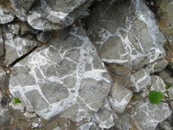
The islands are mostly formed by intrusive igneous rocks, typical of rocks formed underneath central volcanoes and exposed by erosion.
The earlier part of the volcanic activity created a layered gabbro intrusion, which is was later cut by a granite intrusion.
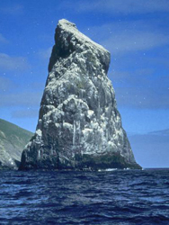
There are also many smaller sheets and dykes that cut through the older rocks – erosion along these lines of weakness is responsible for some of the variety of coastal features including stacks, arches and the ledges utilised by nesting seabirds.
The archipelago was recognised as a World Heritage site in 1986.
Text courtesy of Angus Miller, Scottish Geodiversity Forum
Related Links
Images (Top to Bottom):- Hirta, St Kilda © Mick Crawley (source Geograph.org) Creative Commons Attribution-ShareAlike 2.0 license.
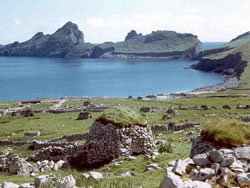
- Ruined houses at Village Bay, St Kilda © Ian Mitchell (Source Geograph.org.uk) Creative Commons Attribution-ShareAlike 2.0 license.
- Good exposure of Mullach Sgar Complex at west end of Village Bay © Rachel Wignall / Scottish Natural Heritage
- Stac Lee from west © Rachel Wignall / Scottish Natural Heritage
![]()
October 13 - 21
Theme: 'Earth Science in our lives'