Beginnings of the map
Reference to the printing and circulation of the Society’s first official publication ‘Geological Inquiries’ in the first minute book, 5 February 1808. Ref: GSL/OM/1/1. No copy of the original has been traced within the Society’s Library collections but the text was reproduced in contemporary journals of the period, such as the Philosophical Magazine in 1817
The origins of Greenough’s map can probably be traced back to the project set out in the newly-formed Geological Society’s first publication, ‘Geological Inquiries’ (1808). The pamphlet was a call to the general public to send in information on what was known about the geology and mineralogy of Britain.
As data poured in, a Committee of Maps was formed on 7 April 1809 as “...the construction of Mineralogical Maps and the collection of Drawings, Models, Sections of Mines, &c, are well worthy the attention of the Geological Society, and cannot fail materially to promote the objects which they had in view of associating.” [Ordinary Minutes of the Geological Society of London, 7 April 1809, GSL/OM/1/1].
Whilst there were plentiful sections being sent in there was very little in the way of geological maps. Therefore in July 1810, Members were informed of the Society’s ambitious plan to create its own geological map of the country. To aid the Society’s effort, Committee of Maps’ member William Atkinson (1774/5-1839) organised the engraving of an outline version of the country based on John Cary’s large map of England & Wales. At a scale of three miles to the inch, the resulting sheets would have been very large. The idea was that Members of the Society would colour in the sheets which corresponded to their local area and send them back for collation. However for a fledgling Society with limited funds, Council decreed that the Members would have to pay to receive the blank map - ten shillings for the complete map, or sixpence per sheet. The accounts for 1813 show that the sale of outline maps generated £7 18s 6d. How successful the plan was is unclear as this figure remained the same in 1814. No reference is made to anyone returning coloured sheets, they certainly do not survive in our Archive.
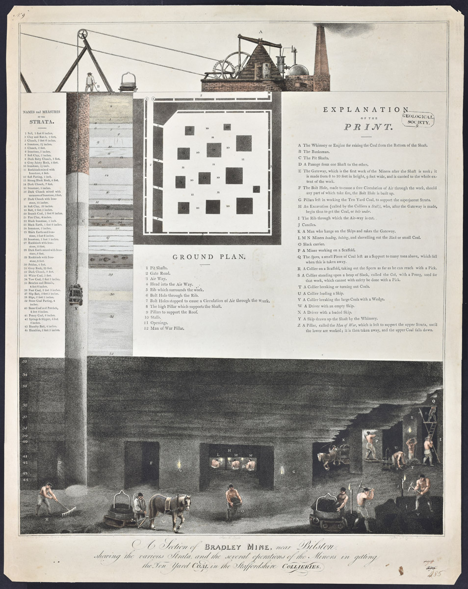 |
'A section of Bradley Mine, near Bilston, shewing the various Strata and the several operations of the Miners in getting the Ten Yard coal in the Staffordshire Collieries’, engraved by Francis Eginton from a painting by D Morris, published by Thomas Westwood, [c.1806]. Ref: LDGSL/421.
Greenough was a member of another committee which was operating concurrently to the Committee of Maps. The Committee of Nomenclature, formed in May 1808, had an initial remit to standardise geological terms. This proved impossible as there were too many regional variations. Instead a short-lived plan to compile a dictionary of these regional terms was proposed, with Members and other interested parties also sending relevant information to the Society.
This print which details the mining terminology used in Staffordshire was donated to the Society by Greenough in November 1810 and therefore could be connected to this committee. Click to enlarge
 |
|
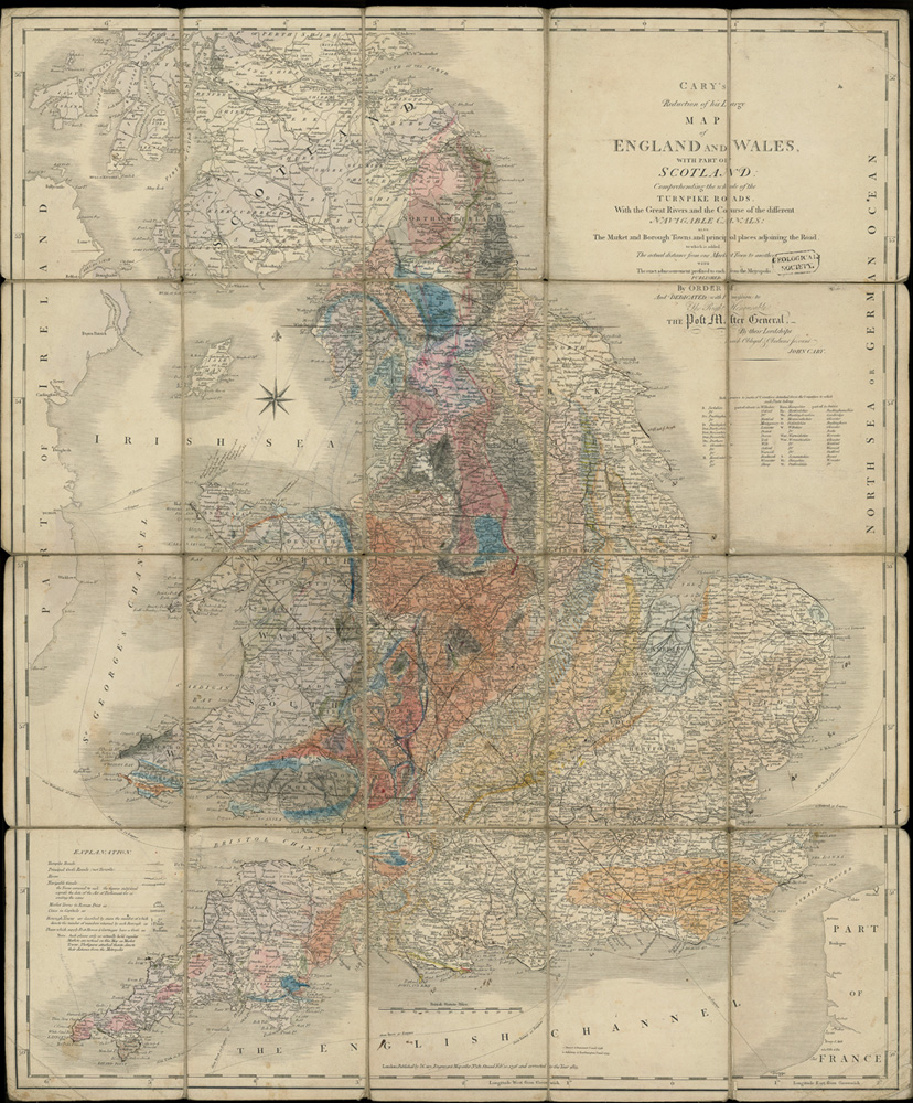
Geological colouring by George Bellas Greenough, [1813-?1815], on base 'Cary's Reduction of his large map of England and Wales with part of Scotland...', published by John Cary, 1813. Greenough collection, ref: LDGSL/947/6/B/2. Click to enlarge |
Curiously George Bellas Greenough was not among the members of this first Committee of Maps, although as President much of the resulting information and data sent to the Society would have been addressed to him. So in parallel to the Committee, Greenough began work on his own version initially consisting of nine maps onto which the main strata of England and Wales were marked. He presented these to the Society in November 1812.
“Although these maps are necessarily in an imperfect state from the want of sufficient materials to render them more complete, yet as they convey a great deal of valuable information, the Council are of opinion that they be offered even now to the public with advantage. They will shew that the Society has advanced considerably in a work which they some time ago announced that they were engaged in viz collecting materials towards a Mineral History of the British Isles; and the best opportunity will thereby be offered of verifying the information already in the possession of the Society. The Council are now engaged in making arrangements for the purpose of publishing these maps without delay.”
From the Annual Report of the Council, 5 February 1813. Archive ref: GSL/CM/6/1.
These nine rudimentary maps do not survive but the map on the right, in Greenough’s map collection, does. It is drafted on a slightly later version of the base map which Greenough used to mark out his basic strata of England and Wales. The colouring is not dated but it could be an early, collated draft.