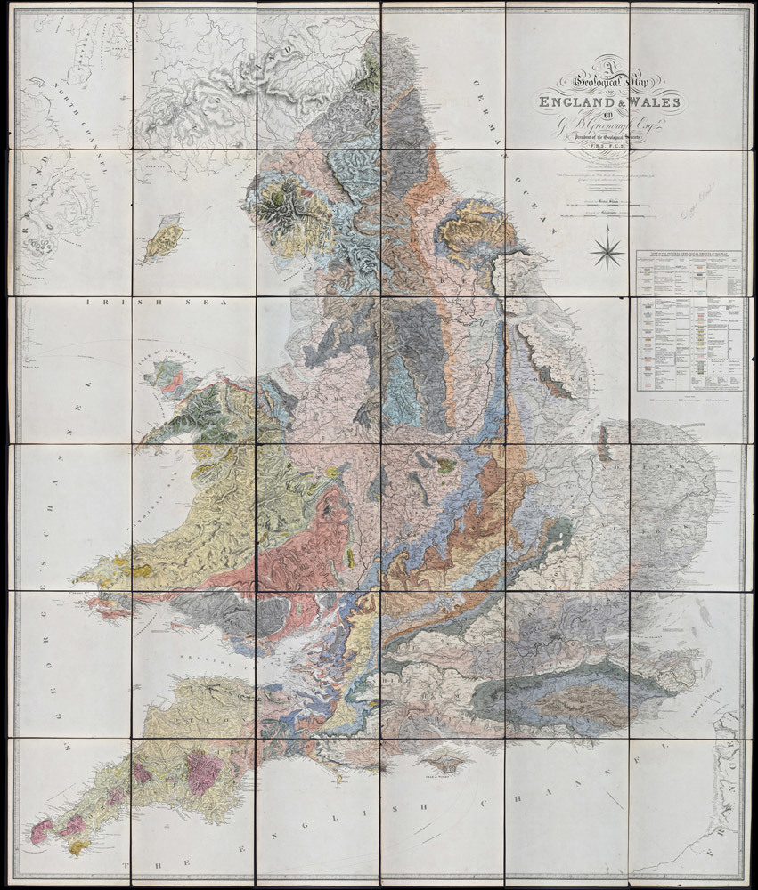
George Bellas Greenough's 'A Geological Map of England and Wales', 1820

Left: Greenough's personal copy of William Smith's 'A Delineation of the Strata of England and Wales...' (1815). (Archive ref: LDGSL/947/6/B/4).
Right: Greenough's 'Geological Map of England and Wales' (1820). (Archive ref: LDGSL/979A/1)
On 13 November 1807, the Geological Society of London was inaugurated at a dinner at the Freemasons Tavern, Great Queen Street, Covent Garden. Despite Smith’s growing reputation and expertise in the subject he was not invited to join, probably due to his lower social and economic status. Nevertheless, in 1808 a delegation of Members of the Society, including George Bellas Greenough (1778-1855) the first president, paid a visit to Smith to see his fossil collection and maps. Apparently not convinced by Smith’s stratigraphical theories or impressed with the slow progress of the map, the Members would subsequently decide that the Geological Society should produce its own official version.
The decision would prove controversial, as although the Society’s map was, like Smith’s, principally the work of one man, unlike Smith, Greenough did not go extensively into the field and study all the geology first hand. Instead much of the information came from others sending him information which he would then collate. Amongst the sources Greenough consulted was William Smith’s Map.
Stung by accusations of plagiarism Greenough later defended his actions:
“…I have been accused of having acted, if not an unfair, at least an ungenerous part, by trespassing upon ground, which I knew to be, by right of pre-occupancy, his [Smith]. I certainly did know, as early as the year 1804, that such a map was begun; but I appeal to all the friends of Mr Smith, with whom I have conversed upon the subject, and especially to the individual who complains of my conduct, whether he, and they did not, for a long time afterwards, in consequence of a variety of circumstances which it is unnecessary to detail, consider its completion, and still more its publication, hopeless. In the belief that the work had been virtually abandoned by Smith, it was undertaken by me.…Mr Smith’s map was not seen by me till after its publication, and the use I have since made of it has been very limited. The two maps agree in many respects, not because the one has been copied from the other, but because both are correct.…”

The Geological Society's Map
Although better supported, both from an intellectual and financial viewpoint, the Society’s geological map still took many years to come to fruition - mainly due to Greenough's fussing over the base map which was drawn and engraved from scratch. The Society’s map, under the official authorship of Greenough, was finally published as ‘A Geological Map of England and Wales’ and dated November 1819, but not actually issued until May 1820.
There are a number of key visual differences between the two men’s maps, most notably the scale – Smith’s at 5 miles to the inch and Greenough’s at 6 miles to the inch. Another distinction is that whilst Smith’s base map has virtually all the topography removed, hills and mountains are included in Greenough’s version. Smith's Map used his distinctive fading watercolour technique, whilst Greenough's employed flat colour washes and patterning to depict his stratigraphy.

Isle of Wight, from Greenough’s personal copy of Smith’s 1815 Map

Isle of Wight as depicted on Greenough’s 1820 Map

Extract from 'Geological Map of the Isle of Wight and the adjacent parts of Hampshire and Dorsetshire', by Thomas Webster, (1815). (Archive ref: LDGSL/510b).
Much has been written on to what extent Smith’s Map influenced Greenough and exactly when the latter actually saw a version of the work, but certainly both the Society and Greenough were amongst the list of subscribers to the publication and each received a copy of the first imprint. Tellingly, the sheets of Greenough’s copy are marked with notes recording that he did indeed consult it, with comments such as 'This sheet can be of no further use to the Geol Map, Nov 1818'.
Despite this rather damning evidence, the reality is far more complicated. Using the depiction of the Isle of Wight, for instance, Greenough’s version is far closer to Thomas Webster’s 1815 geological map of the Isle of Wight than to Smith’s. However, the resemblance between the two is in part explained by Webster being the draughtsman employed to redraw Greenough’s base map.
To read more about the creation of Greenough's 'Geological Map of England and Wales' see the online exhibition: Making Maps - George Bellas Greenough's mapping of the British Isles